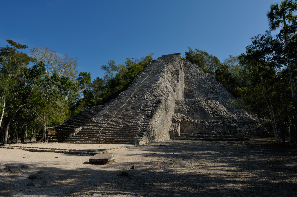
The last Mayan city we visited was Coba, appropriately enough on our last day of the trip. Coba is a large site between Chichen Itza and Tulum. We only had about an hour in the morning to see Coba, so Enrique and I just saw the main pyramid, Nohoch Mul, Stela XX, and that was about it. Lots more to see at Coba. I plan to visit again sometime and see the whole site at a more relaxed pace. What a great way to complete a visit to the Maya lands!
According to the INAH Sign accompanying this site, Coba covers an area of around 70 [square] kilometers (about 27 square miles). Cona has an important network of Saq Beoob (white roads) of varying lengths which connect it to other building groups and settlements. The most notable is Saq Be I, which is 100 kilometers (about 62 1/2 miles) long and reaches the site of Yaxuna, near Chichen Itza. The Mayans built these major roads or causeways between 600 - 800 A.D. They also erected the stelae of Coba during this time period. Archaeologists estimate that the population of Coba in the 8th Century A.D., was about 55,000 people. The Mayans peak construction of Coba occurred between 800 - 1100 A.D. The classical architectural style of Coba resembles more that of the Peten (architectural style) of Guatemala than that of the northern Yucatan. Coba lost its superior force around the Post-Classic Period, and other cities from the coast, such as Tulum, Xcaret, Tankah, and El Rey, began to flourish.
According to the LONELY PLANET: Guide to the Yucatan, 3rd Edition, (2006), ISBN 1-74059-992-6, page 127, the Mayans settled Coba earlier than Chichen Itza or Tulum. Construction reached its peak between 800 and 1100 A.D. Archaeologists believe Coba once covered 50 square kilometers (about 19 1/2 square miles) and had a population of 40,000. Most of Coba’s towering pyramids and stelae resemble the architecture of Tikal, several hundred kilometers away, rather than the much nearer sites of Chichen Itza and the northern Yucatan Peninsula. Some archaeologists theorize that Coba made an alliance with Tikal through marriage to facilitate trade between the Guatemalan and Yucatecan Maya. Stelae at Coba appear to depict female rulers from Tikal holding ceremonial bars and flaunting their power by standing on captives. These Tikal royal females, when married to Coba’s royalty, may have brought architects and artisans with them. Coba is the hub of an extensive network of Sac Beob (“white roads”). The longest Sac Be runs nearly 100 kilometers (about 62 1/2 miles) from the base of Coba’s Nohoch Mul to Yaxuna. Some 40 Sac Beob passed through Coba. Archaeologists estimate that Coba contains some 6,500 structures, of which just a few have been excavated and restored, though work is ongoing.
For additional photos and information, please see the following link: